

加德滿都訊:當8月26日尼泊爾特里舒利河谷出現首批致命洪流的影像時,該地區部分領先的冰川學家正坐在中國邊境對面的四川省一個會議室裡,沮喪地注視著。
其中一些最熟悉喜瑪拉雅山脈的科學家,正在一個地區科學網絡會議上討論監測與理解冰雪圈風險方面的不足之處。
而山脈剛剛展示出牠們驚人的力量。
“真的非常震撼,我相信在冰雪圈科學領域工作了數十年的人也從未預料到如此規模的災難,”特里布漢大學水文與氣象學中央系副教授迪巴斯·施雷斯塔說。
The cryosphere refers to parts of the Earth system where water is frozen.
同一場所的還有米莉娅姆·傑克遜,一位冰川學家與氣候科學家,對喜馬拉雅冰川及其風險有著豐富的研究經驗。她立刻認出這是科學家長期關注的高山風險類型。
“這次事件非常明顯是一個巨大的事件,會造成大量傷亡與嚴重破壞。我當時確實震驚,但說實話,並不算意外,”挪威水資源與能源署的研究科學家傑克遜說。
A bedrock failure high in the mountains had brought down a section of rock and ice, which became a destructive flow travelling more than 100km downstream, something experts have labelled a multi-hazard cascade.
山區高處的岩床崩坍,帶下了一段岩石與冰塊,化為一股具毀滅性的洪流,向下游推進逾百公里,專家稱之為多重風險連鎖。
As of Sep 12, 1,386 people were killed and 5,130 are officially recorded as missing.
截至9月12日,災難已奪去1,386條人命,官方紀錄失蹤人數為5,130人。
災難發生於喜馬拉雅-喀喇昆仑-喀喇帕爾地區的深刻變化之際,這是一條橫跨八國的龐大山系,長約3,500公里,覆蓋了尼泊爾和不丹的全部,及印度、中國、孟加拉、阿富汗、巴基斯坦與緬甸的部分地區。
全球暖化正以快速變化該地區動態的方式影響,該地區被稱為第三極,因為它擁有北極與南極之外最大的雪與冰蓄積。
此地區的氣溫上升幅度約為全球平均水平的兩倍,連同其他氣候變化影響同時作用於冰川、積雪、永久凍土,以及暴露山坡,形成難以預測、難以監測與難以因應的複合風險組合,專家告訴 CNA。
今年發表的研究顯示,尼泊爾朗塘流域的冰川覆蓋高地變暖速度,遠快於低海拔地區,超過三倍以上。
第三極的轉變也威脅在同時帶來更劇烈的災難,並侵蝕下游數十億人口對天然水源的存儲。
這意味著亞洲的高山巨峰正成為日益增長的不確定性的來源。
Snow and glaciers act as natural reservoirs, regulating when and how reliably water flows, explained Benjamin Horton, the dean of the School of Energy and Environment at City University of Hong Kong.
Nearly two billion people depend to varying degrees on river systems originating in the Hindu Kush Himalaya, including the Ganges, Brahmaputra, Indus, Mekong and Yangtze.
“The transformation of the Third Pole is fundamentally a transformation of Asia’s water system,” he said.
“We should be extremely concerned because this is not a smooth transition from too much water to too little. It is likely to be an increasingly unstable period.”
Snow and glacier melt contribution is expected to increase towards mid-century before declining as the frozen reserves diminish, said Mohd Farooq Azam, a senior cryosphere specialist at the International Centre for Integrated Mountain Development (ICIMOD), a regional knowledge institution working across the Hindu Kush Himalaya.
Depending on future warming and location, scientists project the region could lose roughly a-third to more than three-quarters of its current glacier volume by 2100.
Even the eventual disappearance of glaciers would not remove the danger, said Tobias Bolch, glaciologist and professor at Graz University of Technology in Austria, as newly exposed rock would create different hazards.
Glacier loss, extreme heat, heavier rainfall, drought, ocean warming and sea-level rise are all converging as interacting hazards affecting the same people, supply chains and infrastructure systems throughout Asia, Horton added.
“The Third Pole is sometimes described as remote, but there is nothing remote about its consequences.”
UNDERSTANDING THIS DISASTER
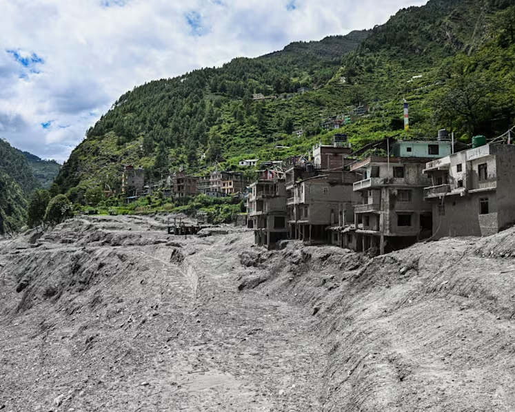
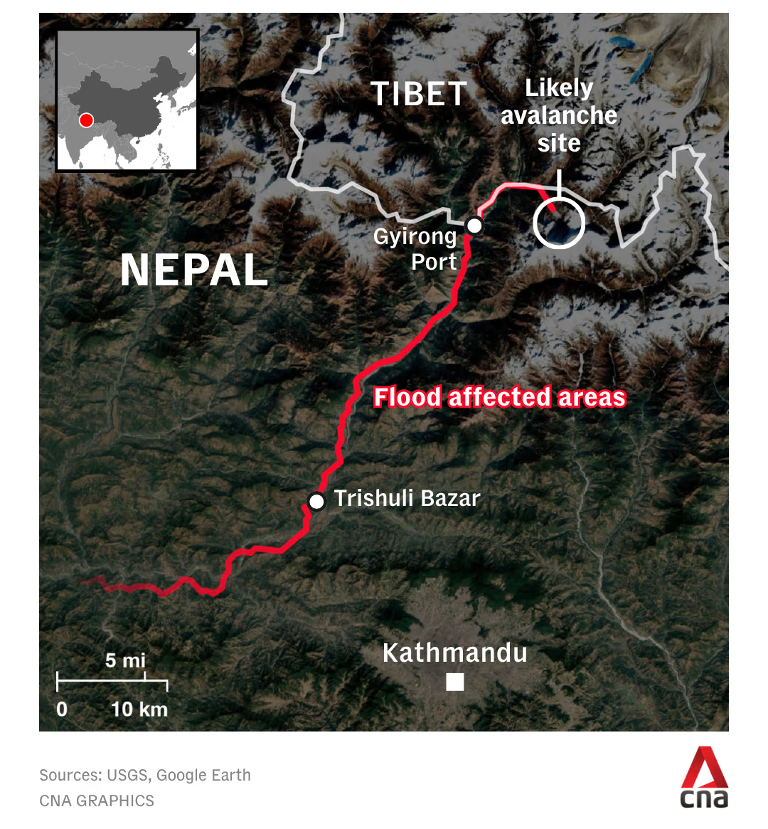
8月26日清晨,科學家發現朗塘-里龍山脈的一大塊岩床與覆蓋其上的冰雪崩落,從大約5,200公尺高度墜落至山谷地面,落差逾2公里。
這次地面衝擊的強度足以讓美國地質調查局報告5.2級地震。
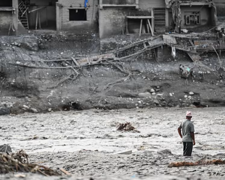
熔融的冰、岩石與碎屑衝入位於西藏高海拔的Lhende Khola 河,之後短暫形成巨湖,然後決裂並向下游沖去,捲帶一路的物件。
對於這次特定失敗的確切機制,研究仍在進行,但科學家認為山區可能同受長期地質過程與氣候變暖的綜合作用而削弱。
當冰川與積雪退去,更多岩石暴露於熱力之中,而暖化亦可能削弱有助於把高山坡嶺黏合在一起的永久凍土,阿札姆說。
博爾赫多年來研究喜馬拉雅地區的冰川。隨著冰川退去,他觀察到有些正從山谷平地往更陡峭的山坡退縮。
在永久凍土區,冰可能牢固地被凍結在下面的岩石上。氣溫上升時,這種黏結會變弱,同時滲入裂縫的融水亦可進一步破壞冰川的穩定,博爾赫說。
“這確實是氣候變化與溫度上升的影響。我很難預測,但我相當確定未來幾年全球會出現類似的情況。”
雖然科學家可以觀察冰川表面,但對冰川底部或內部發生的事情知之甚少,包括可能在這類失敗之前出現的微妙過程,施雷斯塔說。
“有幾個隱藏的故事與跡象,”他這樣形容冰川的內部與底部尚未顯露的部分。
“這些是我們需要更清楚了解的事,以便在未來預測這類災難。”
多年來,研究界與現場觀察多集中於規模龐大且顯眼擴張的冰川湖。當它們突然釋放水量時,便會出現所謂的冰川湖溢洪(GLOF),對山下社區極具危害。
最近的GLOF事件在2023年摧毀了錫金的蒂斯塔谷,及翌年的尼泊爾泰美村,當時一個相對較小的湖泊崩解卻引發下游的另一場災難。
然而8月26日的災難促使科學家把目光越過這些較易監測的風險,轉而關注由吊掛冰川、不穩定岩坡與融化的永久凍土所帶來的緩慢但持續的威脅。
根據對印度-喀喇昆仑-喜馬拉雅地區的估算,該區域約有54,000座冰川,未來識別存在不穩山坡風險的區域,將依賴尖端技術與研究,專家一致認同。
這是一個「大海撈針」的問題,」日內瓦大學與蘇黎世大學的地球科學家及資深研究員西蒙·艾倫說。
他解釋說,對8月26日事件的最新分析顯示,該地區早在2018年就出現移動跡象,並在災難前的幾週加速。
「事後看起來很容易,」他說。「但政府或科學家該如何在事前知道去觀察這個坡度呢?」
這類風險並非新現象。不過如傑克遜所言,挑戰在於它們可能變得更頻繁或更強烈,或在以前未出現的地點出現。
「在不斷變化的環境中,很難說哪些地區是安全的。歷史上安全的地區,可能很快變成最危險的居住地,」她說。
WHAT’S PREVENTING BETTER MONITORING?
Satellites can watch almost every glacier in the Himalayas. But there are scale, data and money problems stymying the most precise and real-time monitoring that could identify dangers before disaster strikes.
The challenge, Jackson said, is that while scientists can identify growing hazards in the mountains, they often cannot say when a catastrophic event will occur.
“When you can’t put a timeline on when things will happen, then the warnings aren’t always taken seriously,” she said.
Azam argued that governments should invest in highly precise commercial imagery and shift from post-disaster investigation towards pre-disaster assessment.
High-resolution imagery often becomes freely available after a disaster, like in the Aug 26 event, which helps explain what happened but not prevent it, Bolch said.
“In a perfect world”, regular high-resolution stereoscopic satellite imagery, using images taken from different angles to track changes in the mountains in three dimensions, could significantly improve monitoring, he said.
The situation is urgent, given the cryosphere is changing much faster than scientists’ ability to understand these processes and develop early warning systems, Azam added.
“It’s like we are trying to catch a train that has already started running on the platform. The train is going faster and faster, and we are trying to catch it,” he said. “There is a big lag.”
Automated space-based monitoring that could detect and alert small movements and changes in the mountains is being developed, but the technology is not ready to be used over large regions like the Hindu Kush Himalaya, said Allen.
“I’d say operationalising such approaches in the Alps is the first step, and then scaling to other larger, more challenging regions,” he said.
Another limit is political. Mountains and rivers frequently cross borders, demanding much better transboundary communication, Jackson said.
Meanwhile, human exposure is growing as tourism, hydropower and other infrastructure expand further into mountain environments. During peak trekking seasons, tourists now outnumber residents in parts of the Langtang Valley.
“In between these extreme events, which are probably going to bring more and more disasters to this region, this is a very tricky situation for the region,” Azam said.
At the same time, Nepal, for example, cannot afford to abandon its rivers, settlements or hydropower. Its steep terrain leaves limited space for settlements and infrastructure, while the country relies overwhelmingly on its rivers for electricity generation.
The latest disaster will force a rethink of how sustainable development could go ahead in mountain regions, Allen said.
“Buzz phrases like ‘building resilient infrastructure’ hold little value when you see the power of an event of that size. You simply cannot engineer solutions for events of this type,” he said.
Infrastructure designed to last 50 or 100 years is still being planned around historical climate conditions that may no longer hold, Horton said.
“The climate of the past has already gone. The danger is that too much of Asia is still being built as though it has not,” he said.
Nepal estimates it will need about US$4.8 billion to rebuild and has appealed for international climate finance and compensation, including from the global Fund for Responding to Loss and Damage.
The government is mapping settlements considered no longer habitable and drawing up plans to rebuild some communities outside flood-risk zones.
Better science and preparedness can reduce the risks, but they cannot make the Himalayas completely danger-free. Scientists say limiting future warming remains critical to slowing the changes already transforming the Third Pole.
“To be honest, I think we cannot avoid these kinds of disasters,” Shrestha said.
“The only way is to adapt and be better prepared. Nowhere in the high mountains is safe.”